
The Lees Ferry gaged flow record
As the point where the river is allocated between the upper and lower basins, Lees Ferry is the "fulcrum" for managing the Colorado River, so it is essential to determine how much water flows past that point. The stream gage at Lees Ferry was installed in 1921, during the Compact negotiations, and has operated continuously since then. For years prior to 1921, gage records upstream and downstream of Lees Ferry were used to estimate the flow at Lees Ferry.
Like most rivers, the natural flow regime of the Colorado River has been altered by human activities. As a result, the gaged streamflow record does not accurately represent the natural long-term trends and year-to-year variability in overall water supply in the basin. The U.S. Bureau of Reclamation has made corrections to the gaged record to account for water depletions (usage) in the upper basin, diversions into and out of the upper basin, and evaporative losses from upper basin reservoirs. The resulting streamflow record is called the "natural flow" record, since it represents what the flow at Lees Ferry would be if the human alterations to the river did not exist. This natural flow record is important because it shows the variability in streamflow due to climate alone, apart from changes in the use and management of the river.
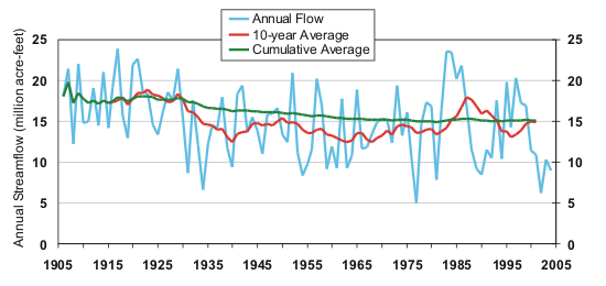
The graph above shows the natural flow record for the Colorado River at Lees Ferry, from 1906-2004. The annual flows are shown in blue, a running 10-year average in red, and a cumulative average in green. Given that the total allocation of water at Lees Ferry is 16.5 million acre-feet (MAF) per year, and actual depletions (use plus evaporation) are now around 14 MAF annually, it is worth noting several features of the natural flow record:
- The annual flows over the past century have varied by a factor of five, from about 5 MAF (1977) to 25 MAF (1984)
- The period from 1906-1930 had 10-year average flows higher than any other part of the record except the mid-1980s
- The cumulative average annual flow declined from about 17 MAF (averaged from 1906-1930) to about 15 MAF (averaged from 1906-2004)
- The 10-year running average has varied from about 12.4 MAF to 18 MAF--in other words, the decadal-scale variability has been high
- From 1934 to 1984, the 10-year running average was almost always below 15 MAF
- The 2000-2004 drought was the most severe multi-year drought in the record, with an average annual flow of 9.6 MAF over those five years
As the 20th century progressed, the observed range of natural variability of Colorado River flows grew ever broader, as "unprecedented" high and low flows were experienced. From this broader frame of reference, it is now apparent that the early period of the record--unfortunately used as the basis for allocating the river's flow--was an unusually wet period.
Does the now 100-year-long natural flow record capture the full range of natural variability of Colorado River streamflow? This seems unlikely, given that in just the past 30 years, the river has seen the two lowest annual flows (1977, 2002) and the two highest annual flows (1983, 1984) on record.

