
Lower Colorado Basin
Introduction
 The Lower Colorado River Basin encompasses nearly all of Arizona, and parts of California, Nevada, Utah, New Mexico and Mexico. While most of the water used within the basin originates in the Upper Colorado River Basin, tributaries within the Lower Basin - most notably the Gila, Salt, and Verde Rivers - are critical in supplying municipal and agricultural needs and supporting unique riparian and aquatic ecosystems.
The Lower Colorado Basin is the "cradle" of modern tree-ring science, and several tree species growing in this drought-stressed climate are ideally suited to studies of past climate. In the early 1900s, researchers from the University of Arizona in Tucson began developing tree-ring chronologies from Douglas-fir, ponderosa pine, and pinyon pine trees. The first "modern" streamflow reconstruction in the Lower Basin was developed in 1981, for the Salt and Verde Rivers. This work continues in the region, and recently, a joint project between the University of Arizona and the Salt River Project generated several new reconstructions for the Gila, Salt, and Verde Rivers. These pages showcase the latest reconstructions, and serve as a portal for accessing the data and other information about past technical workshops and the use of these reconstructions in water management in the basin.
The map below shows the streamflow reconstructions currently available for the lower Colorado River Basin. Place the cursor on a gage icon to view the gage name, and then click to view the page for that reconstruction, and a link to the data. A list of these reconstructions is presented below the map.
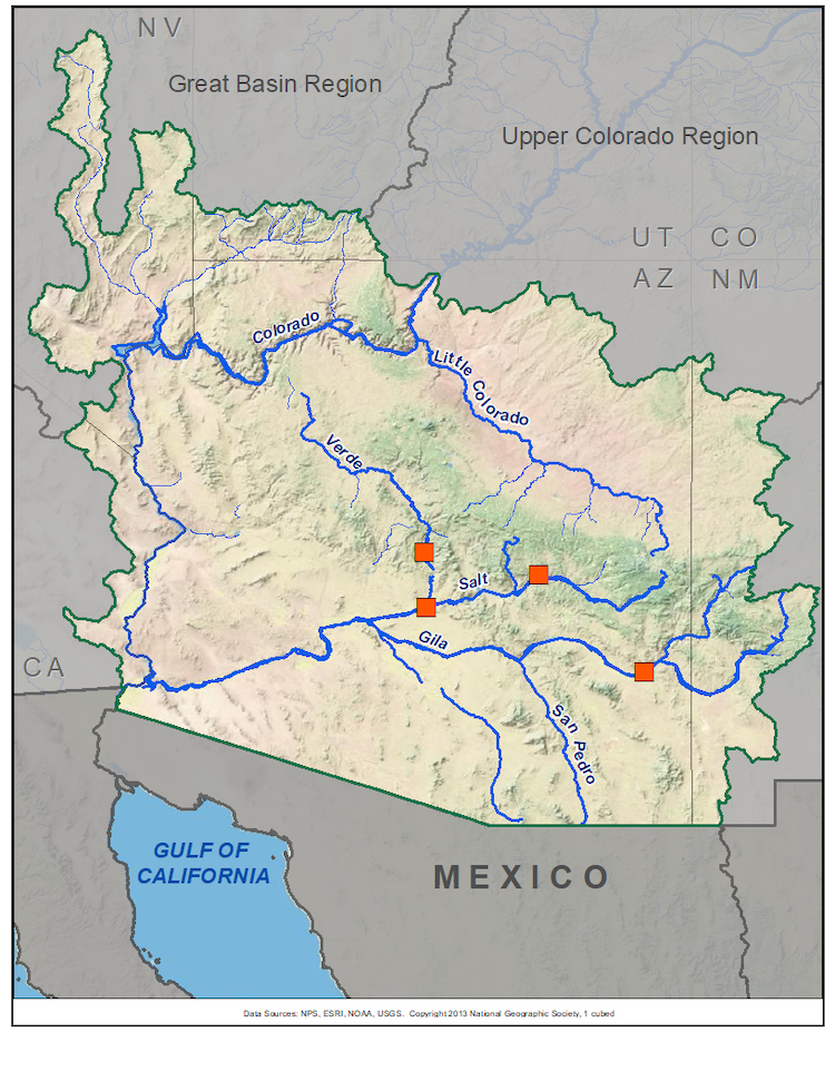
Lower Colorado Basin Reconstructions
| Streamflow Reconstruction Page | Period | Data File |
| Gila River near Solomon | 1332-2005 | gila.txt |
| Salt River - Tonto Creek | 1361-2005 | salt-tonto.txt |
| Salt River - Verde River - Tonto Creek | 1330-2005 | salt-verde-tonto.txt |
| Verde River below Tanglewood Creek | 1330-2005 | verde.txt |
Other Hydroclimatic Reconstructions developed for, or including, the Lower Colorado River Basin:
Cool season (Nov-Mar) precipitation for each climate division in New Mexico and Arizona, extending back 1000 years. (Ni et al. 2002)
Annual (June-June) precipitation for northwestern New Mexico, extending back 2100 years. (Grissino-Mayer 1996)
W presents \"Tree-Ring 101\" at the Boulder City, NV workshop.") e have held four technical workshops for water managers and other stakeholders in the Lower Colorado River Basin. Workshops in Tempe (September 2009), Tucson (November 2006), and in Boulder City, NV (November 2008) comprehensively covered the technical methods of developing streamflow reconstructions from tree rings and provide opportunities for discourse among water managers and researchers. A fourth workshop, in Phoenix in November 2011, was similar but focused on the reconstruction of Southwest monsoon precipitation and applications to water management. Information about the all of our workshops, including instructional presentations, water management application presentations, are available on the TreeFlow Workshops page.
e have held four technical workshops for water managers and other stakeholders in the Lower Colorado River Basin. Workshops in Tempe (September 2009), Tucson (November 2006), and in Boulder City, NV (November 2008) comprehensively covered the technical methods of developing streamflow reconstructions from tree rings and provide opportunities for discourse among water managers and researchers. A fourth workshop, in Phoenix in November 2011, was similar but focused on the reconstruction of Southwest monsoon precipitation and applications to water management. Information about the all of our workshops, including instructional presentations, water management application presentations, are available on the TreeFlow Workshops page.
- Tempe workshop: report and presentations Tucson workshop: report and presentations Boulder City workshop: report and presentations Phoenix workshop: presentations (focus: Southwest Monsoon Precipitation)

There are many different ways to use tree-ring reconstructions in the planning and management for water resources, from educational tools to inform stakeholders about the occurrence of severe droughts, to numerical input into water supply models to test the resilience of the system under past hydrologic conditions. As more water entities use tree-ring data, more strategies for applications are developed. The TreeFlow Applications page page provides summaries of specific applications of tree-ring data around the West, including applications in the Lower Colorado River Basin.
L, of the Laboratory of Tree-Ring Research at the University of Arizona, was one of the first researchers to use tree rings to estimate past streamflows. For more about his work in the Colorado River basin in the 1940s, see Colorado River Streamflow: A Paleo Perspective.") atest streamflow reconstructions (archived on TreeFlow)
atest streamflow reconstructions (archived on TreeFlow)
LTRR-SRP-II. 2008. The Current Drought In Context: A Tree-Ring Based Evaluation of Water Supply Variability for the Salt-Verde River Basin Final Report.http://srp.ltrr.arizona.edu/
Meko, D. M. and K. K. Hirschboeck. Tree-Ring Reconstruction of Streamflow by Scatterplot Smoothing. In preparation. http://fp.arizona.edu/kkh/SRP/SRP2/Recon_Method.pdf
Previous streamflow reconstructions
LTRR-SRP-I. 2005. A Tree-Ring Based Assessment of Synchronous Extreme Streamflow Episodes in the Upper Colorado & Salt-Verde-Tonto River Basin. Final Report. http://srp.ltrr.arizona.edu/
Meko, D.M., and Graybill, D.A. 1995. Tree-ring reconstruction of Upper Gila River discharge: Water Resources Bulletin, v. 31, no. 4, p. 605-616.
Smith, L.P., and Stockton, C.W. 1981. Reconstructed streamflow for the Salt and Verde Rivers from tree-ring data. Water Resources Bulletin, v. 17, no. 6, p. 939-947.
Stockton, C.W., and Jacoby, G.C. 1976. Long-term surface-water supply and streamflow trends in the Upper Colorado River Basin, Lake Powell Research Project Bulletin No. 18: National Science Foundation, 70 pp.
Analyses and Applications of Streamflow and Climate Reconstructions
Graybill, D.A., Gregory, D.A., Funkhouser, G.S., and Nials, F.L. 2006. Long-term streamflow reconstructions, river channel morphology, and aboriginal irrigation systems along the Salt and Gila Rivers, In: Environmental Change and Human Adaptation in the Ancient Southwest, edited by Jeffrey S. Dean and David E. Doyle. University of Utah Press.
O ther climate reconstructions
Cook, E.R., Woodhouse, C., Eakin, C.M., Meko, D.M., and Stahle, D.W. 2004. Long-term aridity changes in the western United States. Science, v. 306, p. 1015-1018.
Grissino-Mayer, H.D., C. H. Baisan, K. A. Morino, and T. W. Swetnam. 2002. Multi-century trends in past climate for the Middle Rio Grande Basin, AD 622–1992. Final Report, USDA Forest Service, Rocky Mountain Research Station, Albuquerque, New Mexico. 58 pp.
Ni, F., T. Cavazos, M. K. Hughes, A. C. Comrie, and G. Funkhouser. 2002. Cool-season precipitation in the Southwestern USA since AD 1000: Comparison of linear and nonlinear techniques for reconstruction. International Journal of Climatology, 22: 1645-1662.

