
California
Introduction

The watersheds which collectively make up the California hydrologic unit span a wide range of climatic, ecological, and land-use conditions, from the wet, sparsely settled northwest basins to the arid Los Angeles basin. Many of these disparate watersheds are tied together by the California State Water Project, which supplies water to over 23 million people and nearly one million acres of irrigated agriculture.
The California Department of Water Resources (DWR) was one of the first water entities to grasp the value of streamflow reconstructions in planning, supporting the development and application of tree-ring data since the 1980s. With the recent development of California blue oak tree-ring chronologies, which are excellent proxies for hydrologic variability, there is even greater potential for the development and use of reconstructions across California. See the California Tree-Ring Chronologies page for more information about existing tree-ring chronologies that could be used to reconstruct streamflow.
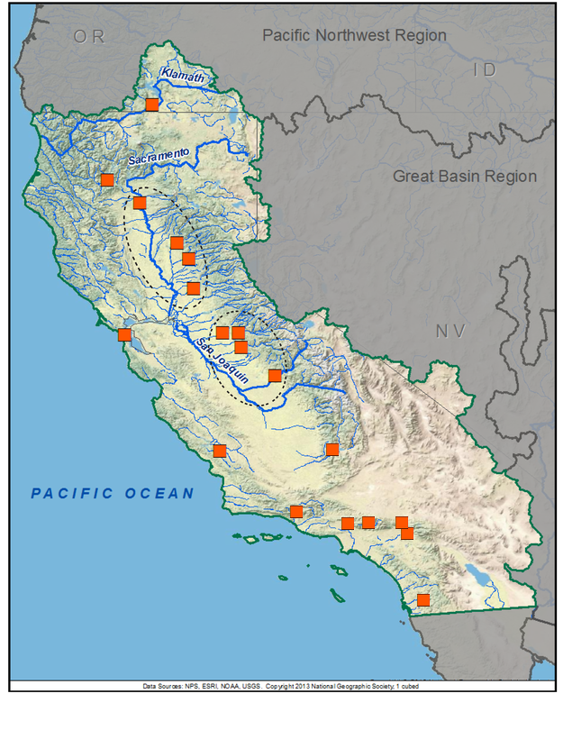
The map below shows the hydroclimatic reconstructions currently available for California. Place the cursor on a gage icon to view the gage name, and then click to view the page for that reconstruction, and a link to the data. A list of these reconstructions is presented below the map.
Also below the map is a list of other streamflow and precipitation reconstructions for California, not shown on the map.
California Basin Reconstructions
Other Streamflow and Hydroclimate Reconstructions
Streamflow Reconstructions
Sacramento River Basin reconstructions
In the mid-1980s, Christopher Earle and Hal Fritts of the University of Arizona's Laboratory of Tree-Ring Research were funded to develop annual streamflow reconstructions for several gages in the Sacramento basin. This work has been superseded by the more recent reconstructions for the Sacramento basin generated by David Meko and colleagues, in 2001, and most recently for the CADWR in 2013.
- Earle, C. J. and H. C. Fritts, 1986. Reconstructing Riverflow in the Sacramento Basin Since 1560. Report prepared for California Department of Water Resources under Agreement No. DWR B-55395
- Earle, C.J., 1993. Asynchronous droughts in California streamflow as reconstructed from tree rings. Quaternary Research 39: 290-299.
- Meko, D.M., Therrell, M.D., Baisan, C.H., Hughes, M.K., 2001. Sacramento River flow reconstructed to A.D. 869 from tree rings. J. Am. Water Resour. Assoc. 37 (4), 1029–1040.
Los Angeles, San Gabriel, Santa Ana, and San Jacinto Rivers, 300 years
In the early 1990s, Daniel Larson of California State University, Long Beach developed an annual streamflow reconstruction (1670-1961) of the average of five gaged flow records in southern California, on the Los Angeles, San Gabriel, Santa Ana, and San Jacinto Rivers. The reconstruction is based on only one tree-ring chronology, and so is not as robust as other streamflow reconstructions. But this reconstruction indicates the excellent potential for future work in these basins.
- Larson, D.O. 1994. California climatic reconstructions. Journal of Interdisciplinary History 25(2): 225-253.
Precipitation Reconstructions
Because precipitation and streamflow are so closely linked, tree-ring reconstructions of precipitation can provide useful information about hydrologic variability. Many precipitation reconstructions have been developed for various parts of California and the surrounding region over the past 20 years. Below are the references in the scientific literature that describe them, roughly ordered from north to south. In a few cases, links to the reconstruction data are provided.
Northern California/Southeastern Oregon, 300 years
- Graumlich, L.J. 1987. Precipitation variation in the Pacific Northwest (1675-1975) as reconstructed from tree rings. Annals of the Association of American Geographers 77(1): 19-29.
Central California, 400 years
- Michaelsen, J., Haston, L., Davis, F.W. 1987. 400 years of central California precipitation variability reconstructed from tree rings. Water Resources Bulletin 23(5): 809-818.
Central coastal California, 400 years
- Haston, L., Michaelsen, J. 1994. Long-term central coastal California precipitation variability and relationships to El Nino-Southern Oscillation. Journal of Climate 7: 1373-1387.
Central California (Sierra Nevada), 1000 years
- Graumlich, L.J. 1993. A 1000-year record of temperature and precipitation in the Sierra Nevada. Quaternary Research 39(2): 249-255.
Central California (Sierra Nevada), 2000 years
- Swetnam, T.W. 1993. Fire history and climate change in giant sequoia groves. Science 262: 885-889.
Central Coastal California, 160 years
- Biondi, F., Cayan, D.R., Berger, W.H. 1997. Dendroclimatology of Torrey pine (Pinus torreyana Parry ex Carr.). American Midland Naturalist 138: 237-251.
Central and Southern California (Sierra Nevada; San Joaquin basin), 1000 years
- Graybill, D.A., Funkhouser, G.S. 1999. Dendroclimatic reconstructions during the past millennium in the southern Sierra Nevada and Owens Valley, California. In: M.R. Rose and P.E. Wigand, eds., Proceedings of the Southern California Climate Symposium: Trends and Extremes of the Past 2000 Years. Natural History Museum of Los Angeles County, Technical Report: 239-269.
Eastern California/Western Nevada (Walker River basin), 2300 years
- Biondi, F., Kozubowski, T.J., Panorska, A.K. 2005. A new model for quantifying climate episodes. International Journal of Climatology 25(9): 1253-1264.
South-central California, 300 years
- Gervais, B.R. 2006. A three-century record of precipitation and blue oak recruitment from the Tehachapi Mountains, Southern California, USA. Dendrochronologia 24(1): 29-37.
Southern California, 400 years
- Haston, L., Michaelsen, J. 1997. Spatial and temporal variability of Southern California precipitation over the last 400 yr and relationships to atmospheric circulation patterns. Journal of Climate 10(8): 1836-1852.
Southwest Nevada (Division 3), 8000 years
- Hughes, M.K., Graumlich, L.J. 1996. Multimillennial dendroclimatic studies from the western United States. In: P.D. Jones, R.S. Bradley, and J. Jouzel, eds., Climatic Variations and Forcing Mechanisms of the Last 2000 Years. NATO ASI Series I41: 109-124. Link to data
Arizona (all 7 climate divisions) and New Mexico (all 8 climate divisions), 1000 years
- Ni, F.B., Cavazos, T., Hughes, M.K., Comrie, A.C., Funkhouser, G. 2002. Cool-season precipitation in the southwestern USA since AD 1000: Comparison of linear and nonlinear techniques for reconstruction. International Journal of Climatology 22(13): 1645-1662. Link to data
Reconstructions of Hydrologic Drought from Relict Trees
Scott Stine of California State University, Hayward has used carbon-dating (not tree-ring cross-dating) of relict stumps rooted in modern lakes, rivers, and marshes in the Sierra Nevada to infer the occurrence of two extraordinary century-long regional droughts, in ~AD 900-1110 and ~AD 1210 to 1350. The timing of these droughts correspond well to drier periods seen in the longer precipitation reconstructions (e.g., Graumlich 1993) listed above, but the magnitude of the droughts suggested by the presence of stumps rooted up to 70 feet below the current lake surface far exceeds those indicated by the tree-ring reconstructions.
- Stine, S. 1994. Extreme and persistent drought in California and Patagonia during mediaeval time. Nature 369:546–49.
- Stine, S. 1998. “A Medieval Climatic Anomaly in the Americas,” in Water, environment, and society in times of climatic change. Edited by A. Issar and N. Brown. Dordrecht and Boston: Kluwer Academic.
Streamflow Reconstructions for the Colorado River basin
Among the seven basin states, California receives the largest apportionment of water from the Colorado River mainstem, and this water represents about 10% of all water used in California. So the hydrologic variability of the Colorado River is of great concern to many California water providers.
New work published since 2006 has greatly increased the number of gage reconstructions available for the Colorado River Basin. See the Upper Colorado Basin homepage and the Lower Colorado Basin homepage for a complete listing of these reconstructions and access to the data.
The Colorado River at Lees Ferry gage is the most important in the basin since it controls the primary apportionment of water in the basin under the Colorado River Compact and subsequent agreements and decisions. Here are direct links to the latest reconstructions of the Colorado River at Lees Ferry:
- Colorado River at Lees Ferry, 1490-1997 (Woodhouse et al. 2006*)
- Colorado River at Lees Ferry, 762-2005 (Meko et al. 2007**)
These reconstructions are very similar and are both excellent reconstructions, with the Meko et al. reconstruction having the advantage of covering a much longer time period.
A detailed history of reconstructions for the Colorado River basin is provided in Colorado River Streamflow – A Paleo Perspective. Charts which compare the Woodhouse and Meko reconstruction, and those two with previous Lees Ferry reconstructions can be found on this page.
- *Woodhouse, C.A., S.T. Gray, and D.M. Meko. 2006. Updated streamflow reconstructions for the Upper Colorado River basin. Water Resources Research 42(5): W05415
- **Meko, D.M., Woodhouse, C.A., Baisan, C.A., Knight, T., Lukas, J.J., Hughes, M.K., and Salzer, M.W. 2007. Medieval Drought in the Upper Colorado River Basin. Geophysical Research Letters 34, L10705.
 presents \"Tree-Ring 101\" at the Boulder City, NV workshop.")
While none of our technical workshops for water managers and stakeholders have been held within California, we partnered with the California Department of Water Resources in the fall 2008 to take part in drought workshops in Santa Rosa and Riverside (links to the tree-ring presentations below).
Tree-ring presentations from the California drought workshops (PDFs):
See the Treeflow Workshops page for general information about the technical workshops for water managers and stakeholders.
C. Woodhouse and D. Griffin - Santa Rosa, CA - October 2008
C. Woodhouse - Riverside, CA - October 2008

There are many different ways to use tree-ring reconstructions in the planning and management for water resources, from educational tools to inform stakeholders about the occurrence of severe droughts, to numerical input into water supply models to test the resilience of the system under past hydrologic conditions.
Descriptions of applications by the California Department of Water Resources and other water agencies in California are coming soon. See the TreeFlow Applications page for descriptions of applications of tree-ring data in other basins around the West.
Latest streamflow reconstructions
Griffin, R.D. 2007. A 600-Year Streamflow History in the Salinas Valley Reconstructed from Blue Oak Tree Rings. M.A. Thesis. University of Arkansas, Fayetteville. 67 pages.
Meko, D. M. 2001. Reconstructed Sacramento River System Runoff From Tree Rings. Report prepared for the California Department of Water Resources, July 2001.
Stahle, D.W., M.D. Therrell, M.K. Cleaveland, D.R. Cayan, M.D. Dettinger and N. Knowles. 2001. Ancient blue oaks reveal human impact on San Francisco Bay salinity. Eos, Transactions, American Geophysical Union. 82(12): 141, 144-145.
Other streamflow reconstructions
Earle, C.J., 1993. Asynchronous droughts in California streamflow as reconstructed from tree rings. Quaternary Research 39: 290-299.
Larson, D.O. 1994. California climatic reconstructions. Journal of Interdisciplinary History 25(2): 225-253.
Meko, D.M., M.D.Therrell, C.H.Baisan, and M.K Hughes, 2001. Sacramento River flow reconstructed to A.D. 869 from tree rings: Journal of the American Water Resources Association 37(4): 1029-1040.
Analyses and applications of streamflow and climate reconstructions
Meko, D.M. and C.A. Woodhouse. 2005. Tree-ring footprint of joint hydrologic drought in Sacramento and Upper Colorado River basins, western USA. Journal of Hydrology, 308, 196-213.
Stahle, D.W., R.D. Griffin, M.D. Therrell, J.R. Edmondson, M.K. Cleaveland, L.N. Stahle, D.J. Burnette, J.T. Abatzoglou, K.T. Redmond, D.M. Meko, M.D. Dettinger, and D.R. Cayan, 2009. The ancient blue oak woodlands of California. Fremontia (in press).
Other climate reconstructions
Biondi, F., Cayan, D.R., Berger, W.H. 1997. Dendroclimatology of Torrey pine (Pinus torreyana Parry ex Carr.). American Midland Naturalist 138: 237-251.
Biondi, F., Kozubowski, T.J., Panorska, A.K. 2005. A new model for quantifying climate episodes. International Journal of Climatology 25(9): 1253-1264.
Cook, E.R., Woodhouse, C., Eakin, C.M., Meko, D.M., and Stahle, D.W. 2004. Long-term aridity changes in the western United States. Science, v. 306, p. 1015-1018.
Gervais, B.R. 2006. A three-century record of precipitation and blue oak recruitment from the Tehachapi Mountains, Southern California, USA. Dendrochronologia 24(1): 29-37.
Graumlich, L.J. 1987. Precipitation variation in the Pacific Northwest (1675-1975) as reconstructed from tree rings. Annals of the Association of American Geographers 77(1): 19-29.
Graumlich, L.J. 1993. A 1000-year record of temperature and precipitation in the Sierra Nevada. Quaternary Research 39(2): 249-255.
Graybill, D.A., Funkhouser, G.S. 1999. Dendroclimatic reconstructions during the past millennium in the southern Sierra Nevada and Owens Valley, California. In: M.R. Rose and P.E. Wigand, eds., Proceedings of the Southern California Climate Symposium: Trends and Extremes of the Past 2000 Years. Natural History Museum of Los Angeles County, Technical Report: 239-269.
Haston, L., Michaelsen, J. 1994. Long-term central coastal California precipitation variability and relationships to El Nino-Southern Oscillation. Journal of Climate 7: 1373-1387.
Haston, L., Michaelsen, J. 1997. Spatial and temporal variability of Southern California precipitation over the last 400 yr and relationships to atmospheric circulation patterns. Journal of Climate 10(8): 1836-1852.
Hughes, M.K., Graumlich, L.J. 1996. Multimillennial dendroclimatic studies from the western United States. In: P.D. Jones, R.S. Bradley, and J. Jouzel, eds., Climatic Variations and Forcing Mechanisms of the Last 2000 Years. NATO ASI Series I41: 109-124.
Michaelsen, J., Haston, L., Davis, F.W. 1987. 400 years of central California precipitation variability reconstructed from tree rings. Water Resources Bulletin 23(5): 809-818.
Ni, F.B., Cavazos, T., Hughes, M.K., Comrie, A.C., Funkhouser, G. 2002. Cool-season precipitation in the southwestern USA since AD 1000: Comparison of linear and nonlinear techniques for reconstruction. International Journal of Climatology 22(13): 1645-1662.
Stine, S. 1994. Extreme and persistent drought in California and Patagonia during mediaeval time. Nature 369:546–49.
Stine, S. 1998. “A Medieval Climatic Anomaly in the Americas,” in Water, environment, and society in times of climatic change. Edited by A. Issar and N. Brown. Dordrecht and Boston: Kluwer Academic.
Swetnam, T.W. 1993. Fire history and climate change in giant sequoia groves. Science 262: 885-889.

