
Upper Colorado Basin
Introduction
T he Upper Colorado River Basin is the source of about 90% of the water in the Colorado River system, and is critical to the water supplies of Denver, Las Vegas, Phoenix, Tucson, Los Angeles, and San Diego, as well as to important agricultural areas. So it’s not surprising that some of the first efforts to use tree rings to reconstruct past hydrologic variability were focused on the Upper Colorado Basin, and the Lees Ferry (AZ) gage in particular has been the subject of at least seven different tree-ring studies (see the Colorado River Streamflow: A Paleo Perspective pages for an overview of these studies).
Since 2000, persistent dry conditions in the basin motivated increasing interest in the tree-ring reconstructions. Now, over 30 gage records have been reconstructed on the mainstem Colorado, its important tributaries, and headwater streams (see map below). These reconstructions utilize a network of over 60 tree-ring chronologies developed in the basin since 2000. The reconstructions have been applied to water planning by the Bureau of Reclamation, Denver Water, the California Department of Water Resources, and others.
The map below shows the streamflow reconstructions currently available for the Upper Colorado Basin. Place the cursor on a gage icon to view the gage name, and then click to view the page for that reconstruction, and a link to the data. A list of these reconstructions is presented below the map.
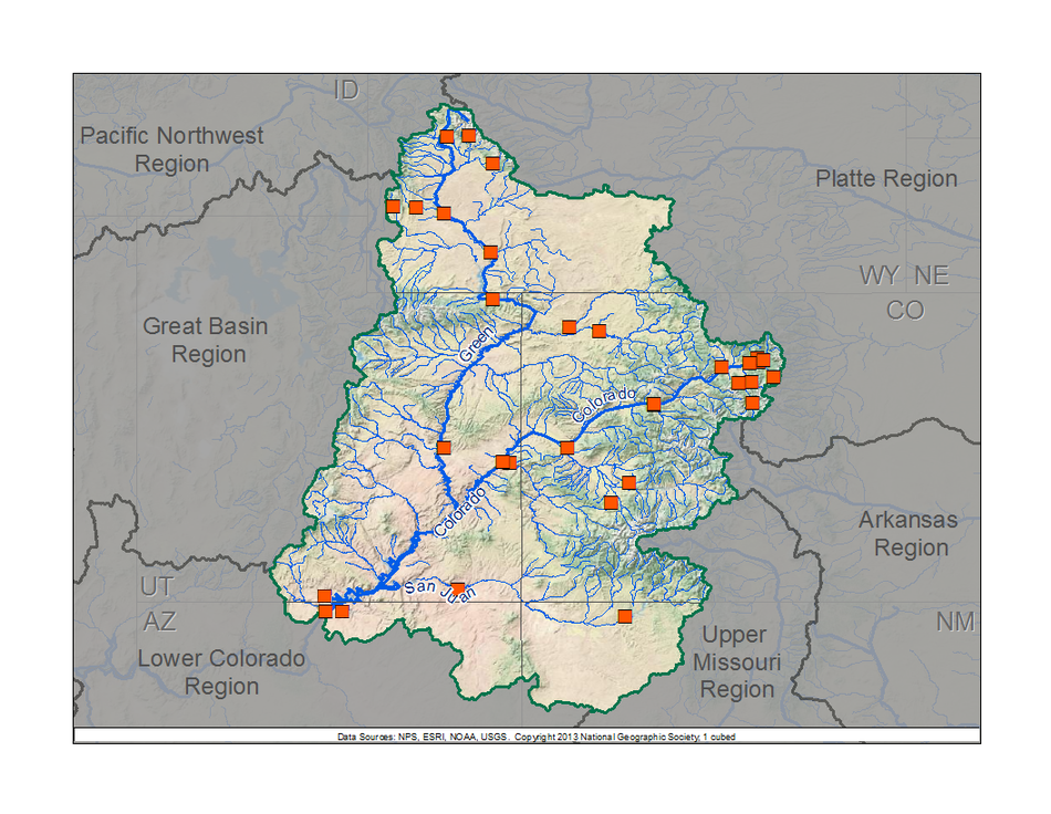
Upper Colorado Basin Reconstructions
Other Hydroclimatic Reconstructions developed for, or including, the Upper Colorado River Basin:
April 1 Snow Water Equivalent, Gunnison River Basin, CO, 1569-1999 (Woodhouse 2003)
Annual Precipitation, Northeastern Utah, 1226-2001 (Gray et al. 2004)
Summer (JJA) Palmer Drought Severity Index (PDSI), covering most of North America on 2.5-degree grid (Cook et al. 2004, 2008)
M presents: Tree-Ring 101, at the Boulder City, NV workshop.") ost of our technical workshops for water managers and stakeholders have been held within the Upper Colorado River basin, or in basins served by water diverted from the Upper Colorado River. These workshops included presentations relevant to the Upper Colorado basin. Click on a workshop below to access a summary report and the presentations; see the Treeflow Workshops page for general information about the workshops.
ost of our technical workshops for water managers and stakeholders have been held within the Upper Colorado River basin, or in basins served by water diverted from the Upper Colorado River. These workshops included presentations relevant to the Upper Colorado basin. Click on a workshop below to access a summary report and the presentations; see the Treeflow Workshops page for general information about the workshops.
 There are many different ways to use tree-ring reconstructions in the planning and management for water resources, from educational tools to inform stakeholders about the occurrence of severe droughts, to numerical input into water supply models to test the resilience of the system under past hydrologic conditions. As more water entities use tree-ring data, more strategies for applications are developed. TheTreeFlow Applications page provides summaries of specific applications of tree-ring data around the West, including several applications in the Upper Colorado Basin, and also the Lower Colorado Basin.
Latest streamflow reconstructions (archived on TreeFlow)
Barnett, F.A., S. Gray and G. Tootle, 2010. Upper Green River Basin (United States) Streamflow Reconstructions. Journal of Hydrologic Engineering, 15(7), 567-579.
Gray, S. T., J. J. Lukas, C. A. Woodhouse. 2011. Millennial-length records of streamflow from three major upper Colorado River tributaries. Journal of the American Water Resources Association, 47(4): 704-712. DOI: 10.1111/j.1752-1688.2011.00535.x. (Abstract)
Meko, D.M., Woodhouse, C.A., Baisan, C.A., Knight, T., Lukas, J.J., Hughes, M.K., and Salzer, M.W. 2007. Medieval Drought in the Upper Colorado River Basin. Geophysical Research Letters 34, L10705.
Woodhouse, C.A., S.T. Gray, and D.M. Meko. 2006. Updated streamflow reconstructions for the Upper Colorado River basin. Water Resources Research 42(5): W05415
Woodhouse, C.A. and J.J. Lukas. 2006. Multi-century tree-ring reconstructions of Colorado streamflow for water resource planning. Climatic Change 78: 293-315.
Previous streamflow reconstructions
Stockton, C.W., and Jacoby, G.C. (1976) Long-term surface-water supply and streamflow trends in the Upper Colorado River Basin, Lake Powell Research Project Bulletin No. 18: National Science Foundation, 70 pp.
Analyses, Applications, and Methods of Streamflow Reconstructions
Barnett, T. P., and D. W. Pierce. 2009. Sustainable water deliveries from the Colorado River in a changing climate. Proceedings of the National Academy of Sciences (PNAS), 106, 7334– 7338, doi:10.1073/pnas.0812762106.
Gangopadhyay, S., Harding, B., Rajagopalan, B., Lukas, J., and Fulp, T. 2009. A Non-Parametric Approach for Paleohydrologic Reconstruction of Annual Streamflow Ensembles. Water Resources Research 45, W06417.
Jain, S., and J. K. Eischeid. 2008. What a difference a century makes: Understanding the changing hydrologic regime and storage requirements in the Upper Colorado River basin. Geophysical Research Letters 35(16): L16401.
Jain, S., C.A. Woodhouse, M.P. Hoerling. 2002. Multidecadal streamflow regimes in the interior western United States: implications for the vulnerability of water resources. Geophysical Research Letters, 29: 2036-2039.
McCabe, G. J., and D. M. Wolock. 2007. Warming may create substantial water supply shortages in the Colorado River Basin. Geophysical Research Letters, v. 34, L22708.
Meko, D.M. and C.A. Woodhouse. 2005. Tree-ring footprint of joint hydrologic drought in Sacramento and Upper Colorado River basins, western USA. Journal of Hydrology, 308, 196-213.
Meko, D. M., C.W. Stockton, and W.R. Boggess. 1995. The tree-ring record of severe sustained drought, Water Resources Bulletin, 31, 789-801.
Nowak, K., M. Hoerling, B. Rajagopalan, and E. Zagona. 2012. Colorado River Basin Hydroclimatic Variability, Journal of Climate, 25 (2), 4389-4403.
Woodhouse, C. A., D. M. Meko, G. M, MacDonald, D. W. Stahle, and E. R. Cook. 2010. A 1200-year perspective on the 21st century drought in southwestern North America. Proceedings of the National Academies of Science (PNAS), 107, 21283-21288.
Woodhouse, C.A. and J.J. Lukas. 2006. Drought, Tree Rings, and Water Resource Management in Colorado. Canadian Water Resources Journal 31(4): 1-14
Other climate reconstructions
Anderson, S., G. Tootle, and H. Grissino-Mayer. 2012. Reconstructions of soil moisture for the Upper Colorado River Basin using tree-ring chronologies. Journal of the American Water Resources Association (JAWRA) 48(4): 849-858. DOI: 10.1111/j.1752-1688.2012.00651.x
Cook, E.R., Woodhouse, C., Eakin, C.M., Meko, D.M., and Stahle, D.W. 2004. Long-term aridity changes in the western United States. Science, v. 306, p. 1015-1018.
Gray, S.T., J.L Betancourt, C.L. Fastie and S.T. Jackson. 2007. Annual precipitation in the Yellowstone National Park region since AD 1173. Quaternary Research, 68(1), 18-27
Gray, S.T., S.T Jackson, and J. L. Betancourt (2004) Tree-ring based reconstructions of interannual to decadal-scale precipitation variability for northeastern Utah since 1226 AD. Journal of the American Water Resources Association 40 (4), 947–960.
Gray, S.T., J.L Betancourt, C.L. Fastie and S.T. Jackson. 2004. Patterns and sources of multidecadal oscillations in drought-sensitive tree-ring records from the central and southern Rocky Mountains, Geophysical Research Letters 10, p. 1316.
MacDonald, G.M., Kremenetski, K.V. and Hidalgo, H. 2008. Southern California and the Perfect Drought: simultaneous prolonged drought in Southern California and the Sacramento and Colorado River systems. Quaternary International 188, 11-23 doi:10.1016/j.quaint.2007.06.027
MacDonald, G.M. and Tingstad, A.H. 2007. Multicentennial precipitation variability and drought occurrence in the Uinta Mountains region, Utah. Arctic, Antarctic and Alpine Research 39, 549–555.
Pederson, G.T.,S. T. Gray, C. A. Woodhouse, J. L. Betancourt, D. B. Fagre, J.S. Littell, E. Watson, B. H. Luckman, L. J. Graumlich. 2011. Evidence from tree rings highlights the unusual nature of recent snowpack declines. Science 333, 332-335. DOI: 10.1126/science.1201570.
Tingstad, A. H. and G. M. MacDonald. 2010. Long- Term Relationships Between Ocean Variability and Water Resources in Northeastern Utah. JAWRA - Journal of the American Wa ter Resources Association 46, 987–1002.
Woodhouse, C.A. 2003. A 431-year reconstruction of western Colorado snowpack from tree rings. Journal of Climate 16: 1551-1561.
For additional resources, see the Other Resources page.

