
Platte Basin
Introduction
The Platte Basin has two principal sub-basins: The North Platte River and its tributaries are used almost exclusively for agriculture in rural north-central Colorado and southern and central Wyoming, while the South Platte River provides most of the water for the urban population of Colorado’s Front Range and also supports extensive agriculture in northeastern Colorado. The native water supply in the South Platte basin is substantially augmented with water diverted from the Upper Colorado basin.
The first tree-ring reconstruction of streamflow in the Platte River basin was developed in 1999. Since then, with increasing interest stimulated by the severe drought in 2002, nine gages have been reconstructed in the South Platte basin, including gages critical to the water supplies of Denver, Boulder, Westminster, and the Northern Colorado Water Conservancy District.
These pages provide access to the latest reconstruction data and information about the use of these reconstructions in water management in the Platte River Basin.
The map below shows the streamflow reconstructions currently available for the PlatteBasin. Place the cursor on a gage icon to view the gage name, and then click to view the page for that reconstruction, and a link to the data. A list of these reconstructions is presented below the map.
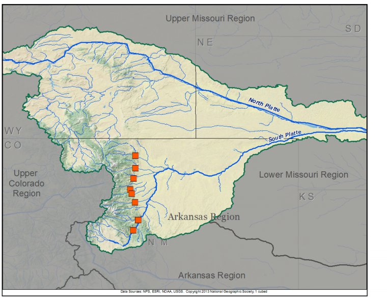
Platte Basin Reconstructions
| Streamflow Reconstruction Page | Period | Data File |
| Cache la Poudre R. at Canyon Mouth, CO | 1615-1999 | poudre.txt |
| Big Thompson R. at Mouth of Canyon, CO | 1569-1999 | bigthompson.txt |
| St. Vrain River at Lyons, CO | 1571-1999 | stvrain.txt |
| Boulder Creek near Orodell, CO | 1566-2002 | boulderorodell.txt |
| S. Boulder Creek near Eldorado Spgs., CO | 1566-2002 | soboulder.txt |
| Clear Creek near Golden, CO | 1566-2002 | cleargolden.txt |
| N. Fork of South Platte R. at South Platte, CO | 1685-1987 | nforksplatte.txt |
| South Platte R. at South Platte, CO | 1634-2002 | splattesplatte.txt |
| South Platte R. below Cheesman Lake, CO | 1685-1987 | splattecheesman.txt |
Other Hydroclimatic Reconstructions developed for, or including, the Platte Basin:
Summer (JJA) Palmer Drought Severity Index (PDSI), covering most of North America on 2.5-degree grid
Eastern Colorado May-June-July PDSI, 1552-1995 (Woodhouse and Brown 2001)
 presents \"Tree-Ring 101\" at the Boulder City, NV workshop.")
Three of our technical workshops for water managers and stakeholders have been held within the Platte basin. These workshops included presentations on data and applications specific to the Platte basin. Click on a workshop below to access a summary report and the presentations; see the Treeflow Workshops page for general information about the workshops.
Boulder, CO - May 2006
Boulder, CO - May 2007
Cheyenne, WY - September 2007

There are many different ways to use tree-ring reconstructions in the planning and management for water resources, from educational tools to inform stakeholders about the occurrence of severe droughts, to numerical input into water supply models to test the resilience of the system under past hydrologic conditions.
Several entities in the Platte Basin have succesfully used tree-ring reconstructions in planning studies. The TreeFlow Applications page has descriptions of applications by the City of Boulder and Denver Water, as well as other applications of tree-ring data from other basins around the West.
Latest streamflow reconstructions
Woodhouse, C.A. and J.J. Lukas. 2006. Multi-century tree-ring reconstructions of Colorado streamflow for water resource planning. Climatic Change 78: 293-315.
Woodhouse, C.A. and J.J. Lukas. 2006. Drought, Tree Rings, and Water Resource Management in Colorado. Canadian Water Resources Journal 31(4): 1-14
Analyses and Applications of Streamflow and Climate Reconstructions
Jain, S., C.A. Woodhouse, M.P. Hoerling. 2002. Multidecadal streamflow regimes in the interior western United States: implications for the vulnerability of water resources. Geophysical Research Letters, 29: 2036-2039.
Woodhouse, C.A. and J.J. Lukas. 2006. Drought, Tree Rings, and Water Resource Management in Colorado. Canadian Water Resources Journal 31(4): 1-14
Other climate reconstructions
Cook, E.R., Woodhouse, C., Eakin, C.M., Meko, D.M., and Stahle, D.W. 2004. Long-term aridity changes in the western United States. Science, v. 306, p. 1015-1018.
External Links
NOAA Regional Integrated Sciences and Assessment Program (RISA)

