
Mid-Atlantic Basin
Introduction
 in northeastern West Virgina whose rings were sampled and incorporated into the streamflow reconstruction of the Potomac River. Photo by Stockton Maxwell")
The Mid-Atlantic Basin is composed of five major river systems: the Hudson River, Delaware River, Susquehanna River, Potomac River, and James River, going from north to south. The basin is home to about one-fifth of the country’s population, with about two-thirds of them living in the urban areas, including New York, Philadelphia, and Washington, D.C., near the coast and/or large rivers. While water resources in the region are generally abundant, periodic drought and pluvial (wet) events require careful management of water resources and the surrounding watersheds to minimize the negative impact of changes in water quantity and quality. Water managers face additional challenges because the Northeast U.S. is predicted to become both warmer and wetter in the coming decades. Increases in precipitation, seasonal streamflow, and a shift to earlier streamflow peaks in the winter and spring are projected. The expected changes in climate and hydrology, in combination with increasing population, will place greater demands on management of the region’s water resources.
Currently, water resource managers in the Mid-Atlantic Basin rely on instrumental records of precipitation and streamflow (<120 years) that are not adequate to assess variability in water quantity within the context of past centuries. Additional information on past variability in streamflow and hydroclimate will help managers better prepare for future changes in water quantity and quality. The signal recorded in moisture-sensitive trees in this region is generally not as strong as that found across much of the western U.S., but is still robust enough to provide useful information about past hydroclimate variability. Thus far, only streamflows for the Potomac River have been reconstructed using tree rings; however, additional reconstructions of drought and precipitation for the Mid-Atlantic Basin exist or are in development.
The map below illustrates the streamflow reconstructions currently available for the Mid-Atlantic Basin. Place the cursor on a gage icon to view the gage name, and then click to view the page for that reconstruction, and a link to the data. A list of the reconstructions available for the Mid-Atlantic Basin is presented below.
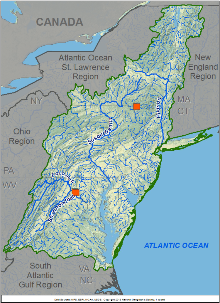
Mid-Atlantic Basin Reconstructions
| Streamflow Reconstruction Page | Period | Data File |
| Beaver Kill River at Cooks Falls, NY | 1675-2000 | beaverkill.txt |
| Potomac River at Point of Rocks, MD (Update) | 1907-2000 | potomac2.txt |
| Potomac River at Point of Rocks, MD | 950-2001 | potomac.txt |
Other Hydroclimatic Reconstructions developed for, or including, the Mid-Atlantic Basin
Mid-Atlantic Region May Precipitation, 1200-1997 - Maxwell et al. 2012
New York City Palmer Drought Severity Index (PDSI), 1531-2003 - Pederson et al. 2013
Montpelier Plantation, Virginia Precipitation, 1784-1966 - Druckenbrod et al. 2003
Jamestown-Roanoke July Palmer Hydrologic Drought Index (PHDI), 1185-1984 - Stahle et al. 1998
Summer (JJA) Palmer Drought Severity Index (PDSI), covering most of North America on 2.5-degree grid - Cook et al. 2004, 2008
 presents \"Tree-Ring 101\" at the Boulder City, NV workshop.")
While none of technical workshops for water managers and stakeholders have been held within the Mid-Atlantic Basin, many of the presentations on data and applications are still relevant to that basin. See the Treeflow Workshops page for general information about the workshops.

There are many different ways to use tree-ring reconstructions in the planning and management for water resources, from educational tools to inform stakeholders about the occurrence of severe droughts, to numerical input into water supply models to test the resilience of the system under past hydrologic conditions.
See the TreeFlow Applications page for descriptions of applications of tree-ring data from other basins.
Latest streamflow reconstructions
Maxwell, R. S., A. E. Hessl, E. R. Cook, and N. Pederson. 2011. A multispecies tree ring reconstruction of Potomac River streamflow (950–2001). Water Resources Research, 47, W05512, doi:10.1029/2010WR010019.
Maxwell, R.S., G.L. Harley, J.T. Maxwell, S.A. Rayback, N. Pederson, E.R. Cook, D.J. Barclay, W. Li, and J.A. Rayburn. 2017. An interbasin comparison of tree‐ring reconstructed streamflow in the eastern United States. Hydrological Processes, 31, 2381–2394.
Other climate reconstructions
Druckenbrod, D., Mann, M.E., Stahle, D.W., Cleaveland, M.K., Therrell, M.D., Shugart, H.H. 2003. Late 18th Century Precipitation Reconstructions from James Madison's Montpelier Plantation. Bulletin of the American Meteorological Society, 84, 57-71.
Maxwell, R.S., A.E. Hessl, E.R. Cook, and B.M. Buckley. 2012. A multi-century reconstruction of May precipitation for the Mid-Atlantic Region using Juniperus virginiana tree rings. Journal of Climate, Early Online Release 20 September 2011. doi: http://dx.doi.org/10.1175/JCLI-D-11-00017.1
Pederson, N., A.R. Bell, E.R. Cook, U. Lall, N. Devineni, R. Seager, K. Eggleston, and K.J. Vranes. 2013. Is an Epic Pluvial Masking the Water Insecurity of the Greater New York City Region? Journal of Climate, Early Online Release 2012 doi: http://dx.doi.org/10.1175/JCLI-D-11-00723.1
Stahle, D.W., M.K. Cleaveland, D.B. Blanton, M.D. Therrell, and D.A. Gay, 1998. The Lost Colony and Jamestown Droughts. Science 280(5363): 564-567.

