
Rio Grande Basin
Introduction
 The Rio Grande is the longest river in southwestern North America, and along its 1900-mile route it supplies critical water resources to agriculture and municipalities (Albuquerque, El Paso, and Ciudad Juarez among them). It also supports unique fisheries and riparian ecosystems along much of its length. Like the Colorado River, the Rio Grande is so thoroughly utilized that it no longer reaches its mouth every year.
Compared to the upper Colorado River basin, the Rio Grande basin is in the early stages of usage of paleohydrologic data. The first reconstructions of annual streamflow in the Rio Grande basin were developed in 2005, for four gages in the upper Rio Grande basin in Colorado. A project in 2007-2008 generated two streamflow reconstructions for the Rio Grande near Otowi, NM. And a project from 2007-2010 generated two reconstructions for the Santa Fe River near Santa Fe.
Trees within and around the upper basin of the Rio Grande contain strong hydroclimatic signals that closely track the cool-season precipitation which drives water-year streamflow. The strong link between cool season precipitation, water year streamflow, and tree growth contributes to high-quality flow reconstructions.
Annual tree-ring widths do not record summer precipitation as well as cool-season precipitation, so in the lower part of the basin where the summer monsoon contributes a much larger proportion of the annual hydrograph, reconstructing water-year streamflow has been challenging. The North American Monsoon project is working to better isolate and apply the tree-ring signal for monsoon precipitation, hopefully leading to improved reconstructions for the lower Rio Grande.
The map below shows the streamflow reconstructions currently available for the Rio Grande Basin. Place the cursor on a gage icon to view the gage name, and then click to view the page for that reconstruction, and a link to the data. A list of these reconstructions is presented below the map.
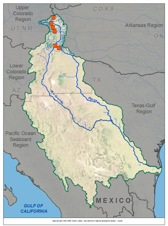
Rio Grande Basin Reconstructions
| Streamflow Reconstruction Page | Period | Data File |
| Rio Grande near Del Norte, CO | 1508-2002 | riograndedelnorte.txt |
| Saguache Creek near Saguache, CO | 1520-2000 | saguache.txt |
| Alamosa River above Terrace Res., CO | 1632-2002 | alamosa.txt |
| Conejos River near Mogote, CO | 1508-2002 | conejos.txt |
| Rio Grande at Otowi, NM (update) | 1450-2012 | riograndeotowiupdate.xls |
| Rio Grande at Otowi, NM (NRCS flows) | 1450-2002 | riograndeotowiNRCS.txt |
| Rio Grande at Otowi, NM (Natural flows) | 1450-2002 | riograndeotowinatural.txt |
| Santa Fe River near Santa Fe, NM (Short) | 1592-2007 | santafeshort-santafelong.xls |
| Santa Fe River near Santa Fe, NM (Long) | 1305-2007 | santafeshort-santafelong.xls |
Other Hydroclimatic Reconstructions developed for, or including, the Rio Grande Basin:
Summer (JJA) Palmer Drought Severity Index (PDSI), covering most of North America on 2.5-degree grid
Annual (June-June) precipitation for northwestern New Mexico, extending back 2100 years (Grissino-Mayer 1996)
F presents: Tree-Ring 101, at the Boulder City, NV workshop.") our of our technical workshops for water managers and stakeholders have been held within the Rio Grande basin. These workshops included presentations on data and applications specific to the Rio Grande basin. Click on a workshop below to access a summary report and the presentations; see the Treeflow Workshops page for general information about the workshops.
our of our technical workshops for water managers and stakeholders have been held within the Rio Grande basin. These workshops included presentations on data and applications specific to the Rio Grande basin. Click on a workshop below to access a summary report and the presentations; see the Treeflow Workshops page for general information about the workshops.
Alamosa, CO - April 2006
Albuquerque, NM - November 2007
Albuquerque, NM - May 2008
Albuquerque, NM - May 2012 (monsoon precipitation)
T here are many different ways to use tree-ring reconstructions in the planning and management for water resources, from educational tools to inform stakeholders about the occurrence of severe droughts, to numerical input into water supply models to test the resilience of the system under past hydrologic conditions.
In 2003, S.S. Papadopolous and Associates (SSPA) conducted a study for the URGWOM project in the middle Rio Grande. SSPA used a tree-ring reconstruction of summer PDSI as a proxy for hydrologic variability, since there were no streamflow reconstructions of the Rio Grande available at that time. SSPA used the reconstructed PDSI to re-standardize the model climatology (1975-1999), then generated synthetic hydrologies, to run in URGWOM, that were reflective of the long-term conditions as expressed in the tree rings. (See Karen MacClune's presentation from the 2007 Albuquerque workshop.)

The City of Santa Fe has contracted with the University of Arizona to develop tree-ring reconstructions of streamflow for the Santa Fe River which can then be run in the City's water supply model. These reconstructions listed above in the Rio Grande Basin Reconstructions, and their development and use is described in Margolis et al. (2011); see the full reference below.
See the TreeFlow Applications page for summaries of other applications of tree-ring data around the West.
Latest streamflow reconstructions
Margolis, E. Q., Meko, D. M., and R. Touchan. 2011. A tree-ring reconstruction of streamflow in the Santa Fe River, New Mexico. Journal of Hydrology, 397(1-2): 118-127.
Woodhouse, C.A., D.W. Stahle, and J. Villanueva-Díaz. 2012. Rio Grande and Rio Conchos water supply variability from instrumental and paleoclimatic records. Climate Research, 51: 125-136. doi: 10.3354/cr01059
Analyses and Applications of Streamflow and Climate Reconstructions
Jain, S., C.A. Woodhouse, M.P. Hoerling. 2002. Multidecadal streamflow regimes in the interior western United States: implications for the vulnerability of water resources. Geophysical Research Letters, 29: 2036-2039.
Lewis, K.J., and D.L. Hathaway. 2002. New Mexico climate and hydrology: Is the Historic Record Valid for Predictive Modeling? Hydrologic Science and Technology. 19, no. 1-4: 57.
Lewis, K.J. and D.L. Hathaway. 2002. Using Paleo-Climate Records to Assess the Current Hydrology of the New Mexico Middle Rio Grande. Southwest Hydrology. 1, no. 2: 20.
Woodhouse, C.A. and J.J. Lukas. 2006. Drought, Tree Rings, and Water Resource Management in Colorado. Canadian Water Resources Journal 31(4): 1-14
Other climate reconstructions
Cook, E.R., Woodhouse, C., Eakin, C.M., Meko, D.M., and Stahle, D.W. 2004. Long-term aridity changes in the western United States. Science, v. 306, p. 1015-1018.
Grissino-Mayer, H.D. 1996. A 2129-year reconstruction of precipitation for northwestern New Mexico, USA. In: J.S. Dean, D.M. Meko, and T.W. Swetnam, eds., Tree Rings, Environment, and Humanity. Radiocarbon, 1996: 191-204.
Grissino-Mayer, H.D., C. H. Baisan, K. A. Morino, and T. W. Swetnam. 2002. Multi-century trends in past climate for the Middle Rio Grande Basin, AD 622–1992. Final Report, USDA Forest Service, Rocky Mountain Research Station, Albuquerque, New Mexico. 58 pp.
Ni, F., T. Cavazos, M. K. Hughes, A. C. Comrie, and G. Funkhouser. 2002. Cool-season precipitation in the Southwestern USA since AD 1000: Comparison of linear and nonlinear techniques for reconstruction. International Journal of Climatology, 22: 1645-1662.
Routson, C.C, C.A. Woodhouse, and J.T. Overpeck. 2011. Second century megadrought in the Rio Grande headwaters,Colorado: How unusual was medieval drought? Geophysical Research Letters, doi:10.1029/2011GL050015.
Touchan, R., C.A. Woodhouse, D.M. Meko, C.D. Allen. 2010. Millennial precipitation reconstruction for the Jemez Mountains, New Mexico, reveals changing drought signal. International Journal of Climatology. DOI: 10.1002/joc.2117 (Abstract)

