
Pacific Northwest
Introduction
The Pacific Northwest hydrologic unit is largely comprised of the US portion of the Columbia River basin, plus the rivers which drain the coastal ranges of Oregon and Washington. The Columbia is the second-largest river in the US in mean annual discharge, and along with major tributaries such as the Snake River, it supports extensive irrigated agriculture, the largest hydropower resource in the US, and important but threatened salmonid fisheries.
Because of the tremendous climatological diversity across the Columbia River basin, reconstructing streamflow for the mainstem Columbia presents greater challenges than other basins, such as the Sacramento River or upper Colorado River, which have more homogeneous climates. In addition, trees in the northern tier of states in the western US have moisture signals which can be weaker and more seasonally complex than their counterparts further south.
Streamflow Reconstructions
In 2004, Gedalof et al. published a reconstruction of annual streamflow for the Columbia River at The Dalles, OR, which used previously collected chronologies primarily from the lower part of the basin. This reconstruction explained only 35% of the variance in the observed flow record, but was a good first step towards more robust reconstructions for the basin.
A NOAA-funded project led by Jeremy Littell, now with the USGS, has resulted in new reconstructions of the Columbia River at The Dalles using an updated and expanded set of tree-ring chronologies. The new reconstructions explain 59% of the variability extending back to 1609, and 52% of the variability extending back to 1502.
Meanwhile, Erika Wise of the University of Arizona's Laboratory of Tree-Ring Research (now at the University of North Carolina) developed new chronologies and reconstructed streamflows at three locations in the upper Snake River, in the southeastern headwaters of the Columbia. This work was completed in 2009 and was archived on TreeFlow in June 2011.
The map below shows the streamflow reconstructions currently available for the Pacific Northwest Basins. Place the cursor on a gage icon to view the gage name, and then click to view the page for that reconstruction, and a link to the data. A list of these reconstructions is presented below the map.
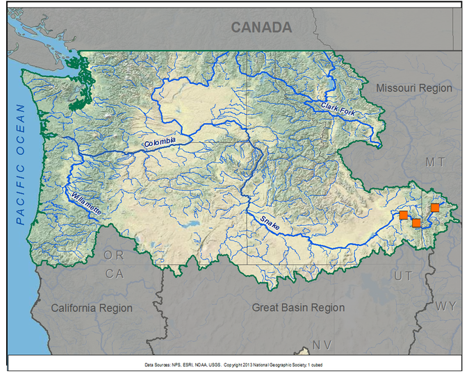
Pacific Northwest Reconstructions
| Streamflow Reconstruction Page | Period | Data File |
| Snake River near Moran, WY (Jackson Lake at Dam) | 1591-2005 | snakemoran.xls |
| Snake River near Irwin, ID (Palisades Dam) | 1591-2005 | snakeirwin.xls |
| Snake River near Heise, ID | 1591-2005 | snakeheise.xls |
| Columbia River at the Dalles | 1502-1983 | columbiadalles.xls |
Other Hydroclimatic Reconstructions developed for, or including, the Pacific Northwest:
Summer (JJA) Palmer Drought Severity Index (PDSI), covering most of North America on 2.5-degree grid
Eastern Oregon Water-Year Precipiation and August PDSI (1705-1979) (Garfin and Hughes 1996)
 presents \"Tree-Ring 101\" at the Boulder City, NV workshop.")
Two workshops for water managers and stakeholders have been held in the Pacific Northwest: Spokane, WA, in May 2008, and Jackson, WY, in June 2011 (by Erika Wise). Click on the workshops below to access a summary report and the presentations; see the Treeflow Workshops page for general information about the series of workshops across the western US.
Spokane, WA - May 2008
Jackson, WY - June 2011

There are many different ways to use tree-ring reconstructions in the planning and management for water resources, from educational tools to inform stakeholders about the occurrence of severe droughts, to numerical input into water supply models to test the resilience of the system under past hydrologic conditions.
In the Pacific Northwest, applications to water management have been limited by the available data. As more data becomes available, we expect water resource applications to soon follow, given the planning challenges posed by regional warming and reduced snowpacks.
See the TreeFlow Applications page for summaries of other applications of tree-ring data around the West.

Latest streamflow reconstructions
Wise, E. K. 2010. Tree ring record of streamflow and drought in the upper Snake River. Water Resources Research, 46, W11529, doi:10.1029/2010WR009282.
Analyses and Applications of Streamflow and Climate Reconstructions
Gedalof, Z., D. L. Peterson and N.J. Mantua. 2004. Columbia River flow and drought since 1750. Journal of the American Water Resources Association. 40: 1579 - 1592.
Wise, E. K. 2011. Incorporating climatological techniques to improve tree-ring site selection in complex terrain. Tree-Ring Research 67 (1), 51-56.
Other climate reconstructions
Cook, E. R., Woodhouse, C., Eakin, C. M., Meko, D. M., and Stahle, D. W. 2004. Long-term aridity changes in the western United States. Science, v. 306, p. 1015-1018.
Garfin, G. M., and Hughes, M. K. 1996. Eastern Oregon Divisional Precipitation and Palmer Drought Severity Index from Tree-Rings. Report to the U.S. Forest Service Intermountain Research Station. USDA Forest Service Cooperative Agreement PNW 90-174.

