Verde River, AZ
 In 2008, David Meko and Katie Hirschboeck, scientists from the University of Arizona Laboratory of Tree-Ring Research, developed a reconstruction of Gila River flow in central Arizona. This reconstruction was part of a larger research project funded by the the Salt River Project, to reconstruct flow in the Salt River watershed. From this project, individual reconstructions were developed for the Gila River, the Verde River, the sum of Salt River-Tonto Creek, and the sum of Salt River-Verde River-Tonto Creek.
Tree-ring cores collected in 2005 were combined with existing collections to produce streamflow reconstructions covering the period 1332-2005. One main conclusion from an analysis of the reconstruction is that despite the single-year severity of drought in 1996 and 2002, the recent drought was by no means unique in the long-term record. Nor was the multi-year persistence of 1996-2006 drought without precedence in the reconstruction. Additional information about this collaborative project is available here.
Methods For the Salt River Project, Meko and Hirschboeck drew from a pool of 25 pinyon pine, Douglas-fir, and ponderosa pine tree-ring chronologies. Using a technique involving principal components analysis, the individual chronologies were filtered, scaled, and weighted for emphasis as a robust estimate of flow for the Gila River. The final calibration model was fit as a Loess curve on the scatter plot of observed flows and the first principal component, as derived from the tree-ring data. Noise-added confidence intervals were calculated with bootstrap sampling of the loess cross-validation residuals. An overview of these methods and the verification procedures are summarized in the final report to the Salt River Project, and explained in detail ina research paper by Meko and Hirschboeck.
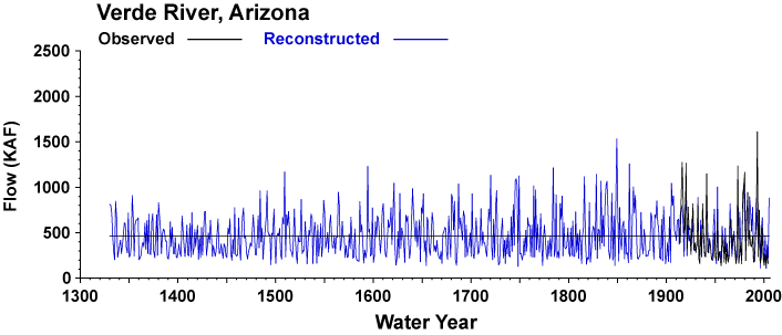
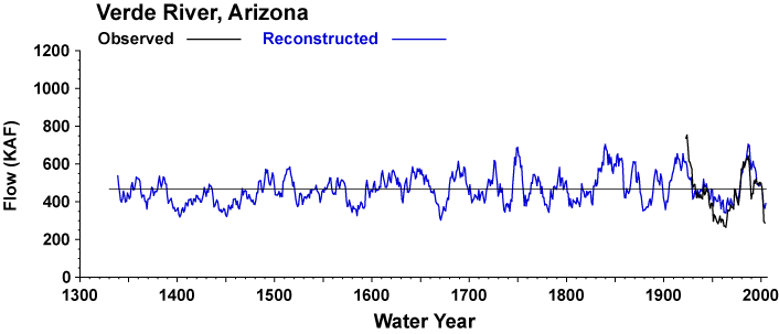
Figures 1 and 2 illustrate the relationship between the gage record and the final reconstruction in scatter and time plots. Figure 3 illustrates the full length reconstruction with confidence intervals and Figure 4 illustrates a 10-year running average of the reconstruction to emphasize long-term variability.

Figure 1. A scatter plot of observed and reconstructed Verde River flow in thousands of acre-feet are shown for water years (October-September) 1914-2004.

Figure 2. Observed (black) and reconstructed (blue) Verde River water year flow in thousands of acre-feet, 1914-2004. The instrumental period mean is shown by the horizontal black line.

Figure 3. Long-term reconstruction of Verde River flow in thousands of acre-feet are shown in blue from 1330-2005 .Observed flow is shown in black, and the long term mean is shown by the horizontal black line. Roll over the images with the cursor to view the 95% confidence limits around the reconstruction.

Figure 4. The ten-year running mean (average flow over 10-year period, plotted for final year) of Salt Verde River flow in thousands of acre-feet, 1330-2005. Reconstructed values are shown in blue, and instrumental values are shown in black. The long term reconstructed mean is shown by the horizontal black line. Roll over the images with the cursor to view the 95% confidence limits around the reconstruction.


